American Revolutionary War · Evidence-led battle guide
Battle of Kip’s Bay
The Battle of Kip’s Bay on September 15, 1776 was an amphibious landing on Manhattan’s East River shore that converted the British victory on Long Island into a direct threat to the American army still spread across lower Manhattan. Naval gunfire, a rapid landing of roughly 4,000 Crown troops, and the collapse of the militia line forced Washington to accelerate the withdrawal toward Harlem Heights. Its importance lies less in a long firefight than in the way sea power, landing-site choice, command uncertainty and road geometry nearly turned an evacuation into an encirclement.
Quick answer
What happened at Battle of Kip’s Bay?
Crown naval fire and the landing force broke the immediate shoreline defense, opened a lodgment on Manhattan and forced American units north and west before a coherent counter-position could be formed.
Why it mattered
The landing compelled the Continental Army to abandon lower Manhattan and concentrate on Harlem Heights. The British gained New York City, but the Americans avoided the more damaging outcome of having major formations trapped south of the landing.
Visual evidence + analytical reconstruction
See the Battlefield, Not Just the Summary
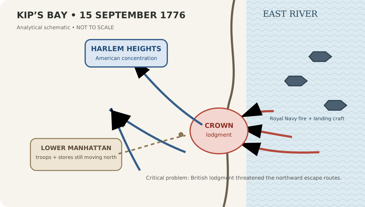
Kip’s Bay amphibious landing and escape-routes schematic
Bellum schematic visualizes the amphibious lodgment and the race to preserve northward escape routes. Not to scale.
BellumReport Research Desk · Original 2026 analytical graphic · Bellum original graphic
Rights: Original explanatory graphic; underlying historical claims require cited evidence.

The British landing at Kip’s Bay
Robert Cleveley, 1777. Near-contemporary artistic representation used to show the maritime character of the landing; not a surveyed map.
Robert Cleveley · 1777 · Wikimedia Commons / Royal Museums Greenwich
Rights: Public domain
Visual-method rule: Bellum analytical schematics are explanatory reconstructions, not surveyed maps. Historical images retain their own source and rights notes so illustration is never presented as direct eyewitness evidence.
Operational geography
Campaign Movement Map
A proportional campaign overview using each battle record’s modern reference coordinate. It explains operational movement; it is not a surveyed reconstruction of 1776 unit positions.
- Battle of Kip’s BayBritish victory
- Battle of Fort LeeBritish victory
- Battle of Mount HollyCrown tactical success; American strategic diversion
- Second Battle of TrentonAmerican defensive success
Campaign sequence
Where This Battle Fits in Its Campaign
Then & now
Battlefield Geography — Historical Ground in the Modern Landscape
Modern reference points are kept separate from claimed 1776 troop positions. A monument, park or surviving house can orient the visitor without proving that a specific unit stood on that exact modern spot.
Kip’s Bay shoreline zone
1776 reference: Kip’s Bay cove on the East River
Modern reference: East Midtown shoreline around East 30s, Manhattan
The 1776 shoreline has been extensively altered and filled; the coordinate is a modern orientation anchor, not a precise landing-point claim.
Location confidence: MediumLost shoreline
1776 reference: 1776 cove and meadow
Modern reference: Modern street grid east of Second Avenue
Urban landfill and development mean the historical water/land boundary cannot be inferred from today’s shoreline.
Location confidence: MediumSource-traceable command structure
Interactive Documented Order of Battle
This tree shows the documented core, not an invented complete roster. Search by formation, commander or battlefield role; expand a row to see source scope, strength basis and disposition. Omitted formations remain unresolved rather than silently classified as absent.
American
CommandContinental Army in New YorkCommand: George WashingtonHigh
Battlefield role: Overall American command during the evacuation of lower Manhattan.
U.S. Army CMH — The New York Campaign, 1776 · High confidence
MilitiaConnecticut militia at the landing sectorCommand: Connecticut militia commanders varied by detachmentHigh
Battlefield role: Thin immediate defense exposed to naval bombardment and landing pressure.
George Washington’s Mount Vernon — Battle of Kip’s Bay · High confidence
CommandLower-Manhattan withdrawal columnCommand: Israel PutnamHigh
Battlefield role: Formations and stores south of the landing had to escape north before routes were cut.
U.S. Army CMH — The New York Campaign, 1776 · High confidence
Crown
CommandBritish expeditionary armyCommand: William HoweHigh
Battlefield role: Overall land command of the Manhattan operation.
U.S. Army CMH — The New York Campaign, 1776 · High confidence
CommandKip’s Bay landing columnCommand: Henry ClintonHigh
Documented strength: 4,000 people (approximately the landing force)
Battlefield role: Senior command associated with the main landing force.
American Battlefield Trust — Lost Battlefield: The Disastrous Battle for New York · High confidence
NavalRoyal Navy East River supportCommand: Richard HoweHigh
Battlefield role: Warships and naval guns supported the amphibious landing.
Wikimedia Commons — The British landing at Kip’s Bay, RMG PAH9491 · High confidence
Read behind the narrative
Primary Source Room
Primary evidence is powerful but not self-interpreting. Each item is paired with why it matters and what it cannot establish by itself.
The British landing at Kip’s Bay, New York Island, 15 September 1776
Creator: Robert Cleveley
Why it matters: A near-contemporary visual representation of the amphibious operation, useful for studying how ships, boats and shoreline action were imagined close to the event.
Read with caution: Made in 1777 and artistic rather than a surveyed plan; visual details cannot be treated as exact troop positions.
Objectives Before the Battle
American objective
Washington’s overriding problem was to preserve the army while removing troops, stores and artillery from lower Manhattan and preventing the landing from cutting the northward escape routes.
British / Crown objective
Howe sought to land a large force on Manhattan, turn the American positions, occupy New York City and place pressure across the roads connecting the lower island with Washington’s northern defenses.
Why Kip’s Bay Was More Dangerous Than a Lost Beachhead
After Brooklyn, Washington’s army still had to solve the problem of Manhattan. The British controlled the waters around New York, which meant Howe could move troops by ship while the Americans depended on roads running along a long, narrow island. By September 12 the American command had accepted that lower New York City could not be held indefinitely, and the removal of stores and troops was underway. The danger was timing. If Howe landed far enough north before the withdrawal was complete, forces remaining in the city could be cut away from Harlem Heights.
Kip’s Bay therefore was not simply a contest for a few hundred yards of shoreline. It was an interception problem. A successful Crown lodgment could place troops across the paths of American units moving north. This is why the speed of the local collapse mattered more than the duration of the firefight. Once the shore defense broke, Washington had to think in terms of routes, marching columns and survival of the army rather than recovery of the bay.
Evidence basis: American Battlefield Trust — Lost Battlefield: The Disastrous Battle for New York
Why the Landing Site Threatened Troops Far from Kip’s Bay
Kip’s Bay lay well north of the dense lower city. A British landing there did not have to destroy every American defender to achieve a major result. It only had to establish enough combat power to menace the roads used by formations still withdrawing from the south. The narrow shape of Manhattan magnified that threat because the defender had fewer ways to bypass a force inserted across the island.
This geographic logic helps explain why Putnam’s withdrawing formations matter to the story even though they were not the shoreline garrison. The tactical map should be read as a race: Crown troops expanding from the East River while American columns sought to pass north. The fact that major American formations escaped is strategically significant. A British victory that captured New York City was serious; a victory that also trapped thousands of Continental soldiers would have been far worse.
Evidence basis: George Washington’s Mount Vernon — Battle of Kip’s Bay
Washington’s Command Crisis Was Larger Than a Moment of Anger
Accounts often highlight Washington trying to rally fleeing soldiers and expressing fury at their behavior. The scene is memorable, but it can distort the command problem if treated as the whole battle. Washington simultaneously had to understand the size of the landing, prevent panic from spreading, preserve the line of retreat and decide where the army could next stand. No local order could undo British control of the water or instantly restore the exposed shore.
The useful leadership question is therefore not whether Washington was angry. It is how command shifts when a tactical position fails faster than expected. At Brooklyn, the army had fallen back into prepared defenses before evacuation. At Kip’s Bay, the danger developed across roads and moving columns. Washington’s priority became preventing tactical disorder from becoming operational encirclement. That transition is the core of Bellum’s Decision Explorer entry for the battle.
Evidence basis: American Battlefield Trust — Lost Battlefield: The Disastrous Battle for New York
Putnam’s Escape Turns a Defeat into a Near-Miss
American troops south of the landing had to move quickly enough to avoid being cut off. Israel Putnam’s column is part of this wider escape problem. The farther British troops pushed across Manhattan, the narrower the margin became for formations trying to reach the northern defenses. The episode demonstrates why battle outcomes cannot be reduced to who possessed the ground at sunset.
The British unquestionably achieved their immediate objective: they landed, broke the defense and occupied lower Manhattan. Yet the American army did not lose all of the formations that Howe’s landing placed in danger. That survival preserved combat power for Harlem Heights and the continuing campaign. Bellum therefore separates “British tactical/operational victory” from “incomplete encirclement.” Both statements can be true, and presenting both is more useful than forcing the action into a single victory label.
Evidence basis: American Battlefield Trust — Lost Battlefield: The Disastrous Battle for New York
What Cleveley’s 1777 Image Can—and Cannot—Tell Us
Robert Cleveley’s depiction of the British landing is unusually valuable because it was produced close to the event and emphasizes the maritime character of the operation: warships, smoke, small boats and troops approaching shore. It helps modern readers visualize something a street-level Manhattan map can hide—the battle began as an amphibious operation supported by naval power.
It is not, however, a measured map. The drawing was produced in 1777, not as a survey taken during the landing, and artistic composition can compress distance or rearrange elements. Bellum labels it as near-contemporary visual evidence, while the original tactical schematic is separately marked “not to scale.” That distinction matters. Historical pictures should enrich understanding without silently becoming proof of exact unit placement.
Evidence basis: Wikimedia Commons — The British landing at Kip’s Bay, RMG PAH9491
From Kip’s Bay to Harlem Heights in One Day
The American retreat did not end the Manhattan campaign. Washington established a stronger position on Harlem Heights, and the next day outpost fighting developed into the Battle of Harlem Heights. This immediate sequence gives Kip’s Bay an unusual role in the campaign: it is both a defeat and the precondition for a very different kind of fight only twenty-four hours later.
At Kip’s Bay the British exploited naval mobility and a weakly held shoreline. At Harlem Heights the Americans fought from a more concentrated northern position and were able to counterattack. Comparing the two pages side by side is therefore more informative than studying either alone. The difference in terrain, force concentration and tactical purpose shows how rapidly the character of fighting could change even within the same Manhattan campaign.
Evidence basis: U.S. Army CMH — The New York Campaign, 1776
The “Cowardice” Explanation Is Too Small for the Battle
The rapid flight of the militia is real and belongs in the narrative. What should be rejected is the idea that it fully explains the outcome. The defenders faced concentrated shipboard fire, a major landing force, an exposed shoreline and a strategic withdrawal already in progress. Morale and discipline were factors inside a much larger operational imbalance.
A stronger explanation asks several questions at once: Why was the landing site difficult to defend? Why could the British concentrate there? How much warning did the Americans have? What happened to the formations south of the lodgment? Why did the army survive despite losing the city? Answering those questions produces a battle page about amphibious warfare, command and evacuation rather than another recycled anecdote about Washington losing his temper.
Evidence basis: American Battlefield Trust — Lost Battlefield: The Disastrous Battle for New York
Kip’s Bay Explains How New York City Was Lost Without a Siege
The British occupation of lower New York did not require a formal siege of the city’s street grid. Once Howe could land above the lower-city positions and Washington chose to preserve the army, the military value of remaining downtown collapsed. This distinction matters because modern readers can imagine a city battle block by block; the 1776 problem was instead defined by control of water approaches, landing sites and the narrow island’s north-south communications.
Kip’s Bay therefore explains the transfer of New York more clearly than a simple statement that the British “captured the city.” The Crown forces created a position from which the Americans could no longer safely hold the lower island. Occupation followed maneuver. That pattern is central to the wider New York campaign, where Howe repeatedly used maritime mobility to alter the geometry of the battlefield before seeking a decisive infantry contest.
Evidence basis: American Battlefield Trust — Lost Battlefield: The Disastrous Battle for New York
Brooklyn and Kip’s Bay Show Two Different Ways an Army Can Be Outmaneuvered
At Brooklyn, the decisive British maneuver used Jamaica Pass to turn the American forward defense on Long Island. At Kip’s Bay, the wider maneuver came from the water: ships and landing craft inserted a force onto Manhattan at a point that threatened the defender’s routes. The mechanisms were different, but both exposed the same American weakness—an army trying to defend too many possible approaches against an enemy with superior operational mobility.
This comparison is why Bellum’s Battle Comparator is not limited to casualties and troop totals. A useful comparison asks what gave each side freedom of movement, which terrain feature became decisive, what information the commanders possessed and whether the defeated army escaped. Brooklyn and Kip’s Bay belong together as studies in operational geometry, yet their tactical experiences were not interchangeable.
Evidence basis: U.S. Army CMH — The New York Campaign, 1776
Forces & Casualties — Evidence, Not False Precision
The charts only compare figures that share a source and measurement definition. Other source-defined figures remain in the evidence table.
No two directly comparable source-defined figures are available yet, so Bellum intentionally does not draw a misleading strength chart.
| Metric | Side | Value | Definition / basis | Source | Confidence |
|---|---|---|---|---|---|
| Strength | Crown | 4,000 | landing force | American Battlefield Trust — Lost Battlefield: The Disastrous Battle for New York | High |
Battlefield Analysis
Terrain
Kip’s Bay offered deep-water access close to Manhattan’s eastern shore and space for troops to come ashore. The tactical geography mattered because a force landing midway along the island could threaten American units still south of the lodgment while roads and high ground to the north shaped the escape toward Harlem.
Intelligence
Washington knew an attack on Manhattan was likely but could not know exactly where Howe would land. The British ability to choose among several shoreline options forced the defenders to spread attention, while the attacker could concentrate boats, ships and infantry at the chosen site.
Turning point
The turning point was the combination of naval bombardment and the first landing wave. Once the thin shoreline defense broke, the problem ceased to be holding Kip’s Bay and became preventing a wider American force from being severed from Harlem Heights.
Logistics
For the Americans, Kip’s Bay was an evacuation under pressure. Wagons, artillery, ammunition and troops had already been moving north before September 15, but the landing compressed the timetable. For the Crown forces, naval transport solved the problem of shifting thousands of men to a selected point faster than Washington could redeploy overland.
Weather
The decisive environmental factor was not unusual weather but maritime access: British control of surrounding waters allowed ships, guns and landing craft to support the operation from the East River.
Where Historical Sources Disagree
Sources commonly agree on the operational result and a Crown landing force of about 4,000, but casualty and American-strength figures are much less stable because some accounts count only the shoreline militia while others include men caught in the wider retreat. Bellum therefore keeps those scopes separate rather than presenting a false single total.
Bellum does not average incompatible figures. Each number below retains its source, definition and confidence.
Battle Timeline & Tactical Phases
- 1
Before the landing
Evacuation already underway
American stores, sick troops and formations were already being shifted north, but significant forces remained in lower Manhattan.
Location: Lower and central Manhattan
Evidence confidence: High - 2
Morning
Naval bombardment opens the landing
British ships in the East River fired on the shoreline defenses, making the exposed militia position difficult to hold.
Location: Kip’s Bay / East River shore
Evidence confidence: High - 3
Morning
Landing force comes ashore
A large Crown landing force reached the Manhattan shore and established a lodgment as the immediate American defense collapsed.
Location: Kip’s Bay
Evidence confidence: High - 4
Late morning
Washington confronts a retreat
The local flight threatened to become an operational disaster because troops farther south still needed routes north past the landing.
Location: Road network north of New York City
Evidence confidence: High - 5
Afternoon
Army concentrates toward Harlem
American formations escaped toward northern Manhattan while the British occupied lower New York and paused short of Washington’s Harlem position.
Location: Harlem Heights approaches
Evidence confidence: Medium
Bellum Decision Explorer
This section evaluates decisions using information and constraints available at the time, not simply whether the eventual outcome was good or bad.
Preserve the army after the Kip’s Bay line breaks
Situation: Washington faced a British lodgment midway along Manhattan while American troops and stores still occupied areas to the south.
What was known: He knew the shoreline defense had broken and that British control of surrounding water allowed Howe to reinforce the landing faster than the Americans could shift troops by road.
Alternatives: Attempt a local counterattack; hold the lower city longer; or accelerate withdrawal toward the northern heights.
Constraints: Time, road congestion, dispersed units and the danger that the landing might sever the northward routes.
Decision: Washington concentrated on getting formations away from the threatened lower island and toward Harlem Heights.
Outcome: The Americans surrendered lower Manhattan but preserved enough of the army to establish a new defensive position and fight at Harlem Heights the next day.
Hindsight guardrail: Hindsight should not treat withdrawal as the same thing as tactical success. The key question is whether preserving the army was preferable to risking encirclement after the shoreline position had already collapsed.
Claim-by-claim provenance
Source Agreement Matrix
This view separates broad source agreement from genuine disagreement. A conflict flag means the stored sources make materially different statements; it does not mean one source is automatically wrong.
1 independent source record in the ledger.
1 independent source record in the ledger.
2 independent source records in the ledger.
2 independent source records in the ledger.
1 independent source record in the ledger.
1 independent source record in the ledger.
Evidence Ledger & Source Trail
The action combined naval bombardment and an amphibious landing on the East River shore.
Wikimedia Commons — The British landing at Kip’s Bay, RMG PAH9491
Robert Cleveley’s 1777 image is a near-contemporary artistic representation, not a measured battlefield map.
Wikimedia Commons — The British landing at Kip’s Bay, RMG PAH9491
Kip’s Bay formed part of the 1776 New York campaign and forced Washington’s army to withdraw toward Harlem Heights.
Army campaign history places the Manhattan withdrawal and ensuing Harlem Heights fighting within the same operational sequence.
The Kip’s Bay landing occurred on September 15, 1776 and produced a British operational success on Manhattan.
American Battlefield Trust — Lost Battlefield: The Disastrous Battle for New York
Mount Vernon likewise places the Kip’s Bay action on September 15, 1776 within the New York Campaign.
American Battlefield Trust describes roughly 4,000 Crown troops landing at Kip’s Bay.
American Battlefield Trust — Lost Battlefield: The Disastrous Battle for New York
The landing threatened American formations still in lower Manhattan and accelerated the evacuation of New York City.
American Battlefield Trust — Lost Battlefield: The Disastrous Battle for New York
Frequently Asked Questions
When was the Battle of Kip’s Bay?
The British landing at Kip’s Bay occurred on September 15, 1776, during the New York Campaign, after the Battle of Brooklyn and one day before the Battle of Harlem Heights.
Source basis: American Battlefield Trust — Lost Battlefield: The Disastrous Battle for New York
Who won the Battle of Kip’s Bay?
The British won the operation. They established a lodgment on Manhattan, broke the immediate American shoreline defense and occupied lower New York City, while Washington’s army withdrew toward Harlem Heights.
Source basis: American Battlefield Trust — Lost Battlefield: The Disastrous Battle for New York
Why was Kip’s Bay strategically important?
A landing midway up Manhattan threatened to cut off American troops still south of the British lodgment. The danger was therefore not merely loss of shoreline ground but potential encirclement of withdrawing formations.
Source basis: George Washington’s Mount Vernon — Battle of Kip’s Bay
How many British troops landed at Kip’s Bay?
American Battlefield Trust describes roughly 4,000 Crown troops in the landing force. Bellum labels this as a landing-force estimate rather than treating it as every British soldier involved in the wider Manhattan operation.
Source basis: American Battlefield Trust — Lost Battlefield: The Disastrous Battle for New York
Is the famous Kip’s Bay image an eyewitness map?
No. Robert Cleveley’s image was produced in 1777 and is a near-contemporary artistic representation. It is useful visual evidence for the amphibious character of the action, but it is not a surveyed troop-position map.
Source basis: Wikimedia Commons — The British landing at Kip’s Bay, RMG PAH9491
What battle came after Kip’s Bay?
The Battle of Harlem Heights followed on September 16, 1776, after Washington concentrated forces on northern Manhattan.
Source basis: U.S. Army CMH — The New York Campaign, 1776