American Revolutionary War · Evidence-led battle guide
Battle of Pell's Point
A delaying engagement in the Westchester phase of the 1776 New York campaign.
Quick answer
What happened at Battle of Pell's Point?
American troops conducted a delaying action against a larger British advance.
Why it mattered
The action contributed to time gained during Washington’s maneuver away from the lower New York positions.
Visual evidence + analytical reconstruction
See the Battlefield, Not Just the Summary
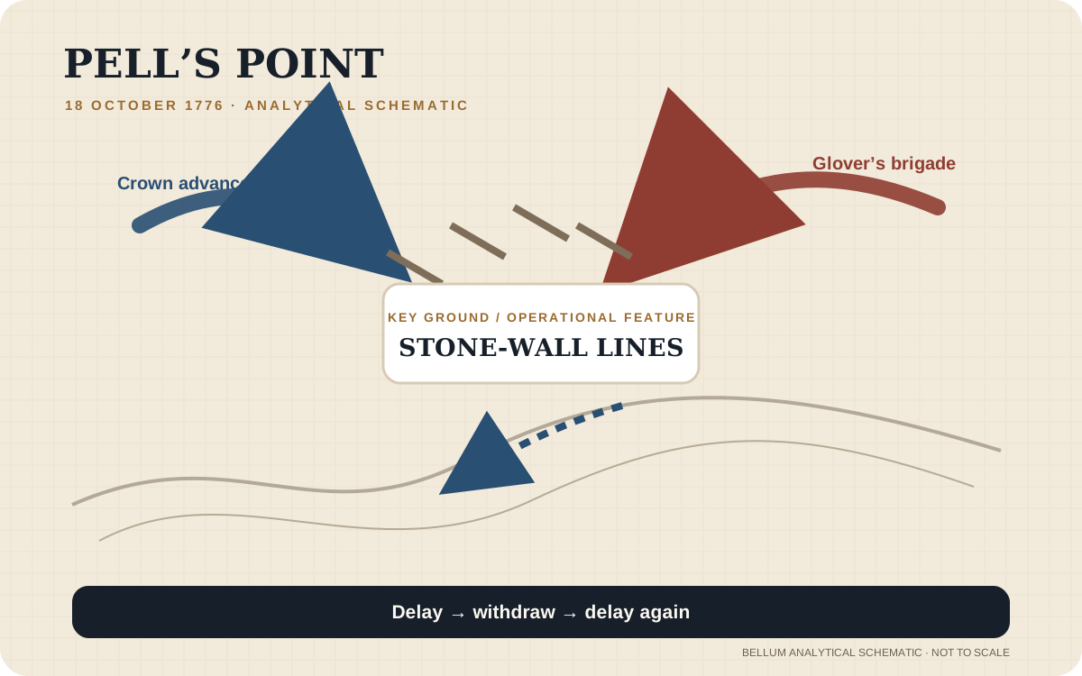
Pell’s Point delaying defense schematic
Bellum schematic highlights repeated defensive positions along the approach, emphasizing time gained rather than territorial control. Not to scale.
BellumReport Research Desk · Original 2026 analytical graphic · Bellum original graphic
Rights: Original explanatory graphic; not a surveyed map.

Pell’s Point area map
Public-domain period map used to orient the reader to the historical landscape.
Samuel Lewis / historic map · late 1700s · Wikimedia Commons / Boston Public Library source
Rights: Public domain
Visual-method rule: Bellum analytical schematics are explanatory reconstructions, not surveyed maps. Historical images retain their own source and rights notes so illustration is never presented as direct eyewitness evidence.
Operational geography
Campaign Movement Map
A proportional campaign overview using each battle record’s modern reference coordinate. It explains operational movement; it is not a surveyed reconstruction of 1776 unit positions.
- Battle of Kip’s BayBritish victory
- Battle of Fort LeeBritish victory
- Battle of Mount HollyCrown tactical success; American strategic diversion
- Second Battle of TrentonAmerican defensive success
Campaign sequence
Where This Battle Fits in Its Campaign
Then & now
Battlefield Geography — Historical Ground in the Modern Landscape
Modern reference points are kept separate from claimed 1776 troop positions. A monument, park or surviving house can orient the visitor without proving that a specific unit stood on that exact modern spot.
Pell’s Point / Pelham Bay battlefield corridor
1776 reference: Pell’s Point landing and stone-wall delaying ground
Modern reference: Pelham Bay Park, Bronx, New York, NY
Modern park reference to the broader action area; surviving markers should not be confused with exact firing positions.
Location confidence: MediumSource-traceable command structure
Interactive Documented Order of Battle
This tree shows the documented core, not an invented complete roster. Search by formation, commander or battlefield role; expand a row to see source scope, strength basis and disposition. Omitted formations remain unresolved rather than silently classified as absent.
American
BrigadeGlover’s temporary Massachusetts brigadeCommand: John GloverHigh
Documented strength: 750 people (Army CMH approximate strength)
Battlefield role: Conducted a controlled delaying action from successive stone-wall positions.
U.S. Army CMH — The New York Campaign, 1776 · High confidence
Crown
ColumnCrown advance from Pell’s PointCommand: Charles CornwallisMedium
Battlefield role: Advanced inland from the landing and was delayed by Glover’s brigade.
U.S. Army CMH — The New York Campaign, 1776 · Medium confidence
Read behind the narrative
Primary Source Room
Primary evidence is powerful but not self-interpreting. Each item is paired with why it matters and what it cannot establish by itself.
John Glover’s report of the Pell’s Point action, October 1776
Creator: John Glover
Why it matters: Glover’s own report is the central first-person command account for the delaying action and is especially valuable for sequence and tactical intent.
Read with caution: The linked item is a later publication/transcription rather than the manuscript repository; wording and editorial framing should be checked against the earliest accessible text before quotation.
Objectives Before the Battle
American objective
Glover’s brigade needed to delay the British advance long enough to support the main American withdrawal toward White Plains.
British / Crown objective
Howe sought to turn Washington’s position, threaten the American line of retreat and bring the main army to a disadvantageous engagement.
Why Pell’s Point Was More Important Than Its Size Suggests
Pell’s Point was a delaying action fought during the British attempt to maneuver around Washington’s army in October 1776. NPS describes Colonel John Glover’s brigade—about 750 Massachusetts troops—facing an attacking force of roughly 4,000 British and Hessian soldiers. The Americans could not expect to defeat the entire Crown force in a prolonged battle. Their practical task was to delay it while the main American army moved toward White Plains.
The result is best judged against that mission. Glover eventually withdrew, and the British advance continued, but the larger force had been slowed by a much smaller brigade. Pell’s Point therefore shows why possession of the field is not always the same thing as operational success: time gained for another formation can be the decisive output of a rear-guard action.
Evidence basis: NPS — The Battle of Pell's Point
How Howe Tried to Turn Washington’s Position
In mid-October, Howe used amphibious movement through Long Island Sound and the East River approaches to threaten Washington’s rear and supply connections. An earlier landing at Throgs Neck was checked by difficult ground and American resistance. On October 18, Crown forces shifted to Pell’s Point, where the landing offered another route toward the American line of retreat.
The action formed part of a larger attempt to get beyond Washington’s position rather than simply drive straight through it. If the British could move faster inland than the Americans could withdraw, they might force a disadvantageous general engagement or sever escape routes. Glover’s brigade fought within that operational race for roads, crossings and time.
Evidence basis: NPS — The Battle of Pell's Point
John Glover’s Staggered Stone-Wall Defense
NPS describes Glover placing his regiments at staggered intervals behind stone walls along the road. The position allowed successive American groups to deliver close-range volleys and then fall back toward another prepared line. This created a layered delaying defense rather than a single static stand.
That method is why the battle deserves a tactical-phase treatment. The value was created by repeated withdrawal and re-engagement: each position imposed another delay while keeping the brigade from being fixed and destroyed too early.
Evidence basis: NPS — The Battle of Pell's Point
Why Glover Eventually Withdrew
As additional British and Hessian troops entered the action, Cornwallis completed a flanking movement that threatened the American left. Glover then ordered a withdrawal across the Hutchinson River and later moved north toward White Plains. The Crown force did not aggressively pursue the brigade after the action.
The withdrawal was consistent with the purpose of a delaying defense. Glover’s regiments were not positioned to hold Pell’s Point indefinitely against a force several times their size. Once the danger of envelopment increased, preserving the brigade and continuing the movement north became more important than remaining behind the final stone wall.
Evidence basis: NPS — The Battle of Pell's Point
Stone Walls, Roads and the Hutchinson River
Pell’s Point shows how local terrain can compensate partly for numerical inferiority. Roads constrained movement, stone walls provided cover, and the Hutchinson River formed a line around which the defenders could organize their retreat. NPS identifies the fiercest fighting near Split Rock and places much of the movement along routes that can still be related to the modern Bronx and lower Westchester landscape.
The stone-wall tactic worked because each position delayed the Crown advance without requiring Glover’s brigade to remain fixed until overwhelmed. A map of the battle should therefore emphasize the sequence of positions and withdrawals rather than present one static battle line. Split Rock is a useful anchor, while the connecting movement corridors require more cautious reconstruction.
Evidence basis: NPS — The Battle of Pell's Point
The Strategic Value of Time
The main American army’s survival depended repeatedly on avoiding encirclement while yielding ground. Pell’s Point helped buy time during that process. The result illustrates a broader military principle: the value of a battle is not always measured by possession of the field. A smaller force can succeed strategically by delaying an enemy long enough for another operation to occur.
For Washington, the practical benefit was movement space. The main body continued toward White Plains while the British advance lost time against Glover’s successive positions. The engagement therefore belongs in the campaign story as a successful delaying action even though the Crown force remained free to advance after the fighting ended.
Evidence basis: NPS — The Battle of Pell's Point
Pell’s Point Was Part of Howe’s Attempt to Get Around Washington
The action at Pell’s Point grew from a larger British maneuver rather than from a search for a small independent battle. Howe wanted to use amphibious mobility to place Crown forces in Westchester, threaten the American line of retreat and force Washington into a dangerous position. The landing near today’s Pelham Bay Park therefore belonged to the same operational contest that had already pushed the Americans out of lower Manhattan.
NPS describes an attacking force of about 4,000, including British light infantry, grenadiers and dismounted light dragoons. The landing itself was largely unopposed. The challenge for the Americans was not to throw that force back into the water; Colonel John Glover had only about 750 soldiers in four Massachusetts regiments. His practical mission was to interfere with the advance and buy time for the main Continental Army moving toward White Plains.
That mission changes how success should be judged. If the standard is possession of the landing area, Glover lost ground. If the standard is whether a much smaller force could slow a larger enemy without being destroyed, withdraw before envelopment and help protect the main army’s movement, the action looks very different. Pell’s Point is a classic example of tactical withdrawal serving an operational purpose.
Evidence basis: NPS — The Battle of Pell's Point
The Spyglass Moment Shows How Fast Glover Had to Build a Defense
NPS recounts Glover climbing a hill early on October 18 and using a spyglass to observe British forces moving into Eastchester Bay. That moment is more than a colorful detail. It marks the transition from uncertainty to a rapidly constructed defensive plan. Glover did not have days to build formal works or reposition a large army. He had to interpret what he saw, estimate the enemy’s direction and use the ground immediately available.
His response was to organize successive positions along the road network rather than mass every regiment at a single point. Stone walls bordering Split Rock Road provided concealment and cover. Troops could fire at close range, then fall back toward another prepared line as pressure increased. This arrangement multiplied the defensive value of a small force because the British repeatedly had to deploy against new resistance instead of simply brushing past one isolated skirmish line.
The method also depended on discipline. A staged withdrawal fails if one regiment leaves too early, stays too long or blocks the movement of the next line. Glover’s design therefore combined terrain with timing. The walls did not stop the British by themselves; they gave trained soldiers positions from which controlled volleys and planned movement could impose delay.
Evidence basis: NPS — The Battle of Pell's Point
St. Paul’s Church Connects the Battlefield to the Human Cost of Campaigning
The Pell’s Point landscape included more than roads and firing positions. St. Paul’s Church had been used as a hospital by American forces before the British advance changed control of the area. After Glover withdrew, Hessian forces also used the church as a field hospital. That continuity is a reminder that the campaign moved through civilian buildings and communities whose functions changed as armies passed.
A hospital site also broadens the meaning of “battlefield.” Combat casualties were only part of an eighteenth-century army’s medical burden. Sick soldiers, transport of patients and the availability of substantial buildings all affected military movement. The British approach forced the Americans not only to reposition troops but also to deal with vulnerable men and medical facilities behind the line.
For a modern visitor, the church provides a surviving physical anchor for an action whose road network has been heavily altered by later development. It helps connect the abstract sequence—landing, stone-wall defense, withdrawal across the Hutchinson River—to a place that served both armies. The page therefore treats St. Paul’s as part of the campaign system, not as an unrelated monument added after the battle narrative.
Evidence basis: NPS — The Battle of Pell's Point
Cornwallis’s Flanking Movement Set the Limit of the Delaying Action
A delaying defense is successful only if it ends before delay becomes encirclement. By around noon, NPS says Cornwallis had completed a flanking movement against the American left. At that point Glover faced a different problem from the one he had managed during the morning. Successive stone-wall positions could continue to slow troops advancing along the road, but they could not safely solve an enemy movement that threatened the brigade’s route of escape.
Glover therefore ordered a withdrawal across the Hutchinson River. This was not evidence that the earlier defense had failed; it was the decision that preserved the force after the delaying mission had extracted as much time as the position could safely provide. The brigade later moved north toward White Plains, while the Crown forces did not immediately pursue.
The tactical lesson is specific. Good defensive terrain can create temporary local superiority for a smaller force, but flanking changes the geometry. Once the enemy can bypass the strong point, staying to defend it may turn an advantageous position into a trap. The moment when Glover chose to leave is consequently as important as the volleys from behind the stone walls. It shows command judgment about when a useful position has stopped being useful.
Evidence basis: NPS — The Battle of Pell's Point
Why the Lack of Immediate British Pursuit Matters
After Glover withdrew across the Hutchinson River, NPS notes that the British did not immediately pursue his brigade. That fact helps measure what the delaying action accomplished. Glover had not destroyed the landing force, but he had imposed enough friction and caution that the much larger Crown column did not simply roll through the American withdrawal line at full speed.
A delay can be strategically valuable even when it leaves no captured guns, occupied town or conventional victory trophy. Time gained allows other formations to move supplies, choose positions and avoid being caught during vulnerable movement. In the context of October 1776, Washington’s main army needed exactly that commodity while shifting toward White Plains. Glover’s brigade created it by forcing Howe’s advancing troops to deploy, fight, bring forward additional forces and respond to successive defensive positions.
The absence of pursuit also confirms that Glover ended the action at the right moment. His force remained coherent enough to cross the river and move north rather than being broken during the withdrawal. The battle’s value is therefore best seen in the relationship between hours spent by the Crown advance and freedom gained by Washington’s larger army.
Evidence basis: NPS — The Battle of Pell's Point
Forces & Casualties — Evidence, Not False Precision
The charts only compare figures that share a source and measurement definition. Other source-defined figures remain in the evidence table.
| Metric | Side | Value | Definition / basis | Source | Confidence |
|---|---|---|---|---|---|
| Forces Engaged | American | 750 | NPS Pell's Point battle narrative | NPS — The Battle of Pell's Point | High |
| Forces Engaged | British/Hessian | 4,000 | NPS Pell's Point battle narrative | NPS — The Battle of Pell's Point | High |
Battlefield Analysis
Terrain
Roads, stone walls, marshy ground and the Hutchinson River favored a staged delaying defense.
Intelligence
Glover observed the British movement and rapidly arranged his regiments in successive defensive positions.
Turning point
Cornwallis’s flanking movement threatened the American left, prompting Glover to end the delaying action and withdraw.
Battle Timeline & Tactical Phases
- 1
Early morning, October 18
Crown landing at Pell’s Point
British forces landed near Pell’s Point while another column approached through the Westchester area.
Location: Pelham Bay / Eastchester Bay approaches
Evidence confidence: High - 2
Morning
Glover establishes staggered defensive lines
Glover placed Massachusetts regiments behind successive stone walls to create repeated close-range defensive positions.
Location: Split Rock Road corridor
Evidence confidence: High - 3
Late morning
Successive volleys and withdrawals
American units fired from cover, withdrew, and rejoined troops at the next line, slowing the larger Crown force.
Location: Road network west of landing area
Evidence confidence: High - 4
Around noon and after
Flank threat and American withdrawal
With Cornwallis threatening the American left and more Crown troops entering the action, Glover withdrew across the Hutchinson River and moved north.
Location: Hutchinson River toward Tuckahoe/White Plains
Evidence confidence: High
Bellum Decision Explorer
This section evaluates decisions using information and constraints available at the time, not simply whether the eventual outcome was good or bad.
Use successive stone-wall positions instead of a single stand
Situation: Glover’s roughly 750 men faced a Crown force several times larger while Washington’s main army was withdrawing.
What was known: Glover could observe the advancing force and had terrain with roads and stone walls suitable for short defensive stands.
Alternatives: Withdraw immediately; hold one fixed line; conduct a mobile delaying defense through successive covered positions.
Constraints: Severe numerical inferiority, risk of flanking, requirement to preserve the brigade while buying time.
Decision: Glover arranged staggered regimental positions and withdrew units through successive defensive lines after firing.
Outcome: The brigade delayed the Crown advance and then withdrew when the flank threat became too dangerous.
Hindsight guardrail: The decision is judged against the delaying mission, not against the impossible standard of defeating Howe’s entire force.
Claim-by-claim provenance
Source Agreement Matrix
This view separates broad source agreement from genuine disagreement. A conflict flag means the stored sources make materially different statements; it does not mean one source is automatically wrong.
1 independent source record in the ledger.
Evidence Ledger & Source Trail
Pell's Point formed part of the New York campaign of August through December 1776.
NPS — The Battle of Pell's Point · Article introduction
Frequently Asked Questions
When was the Battle of Pell’s Point?
The battle was fought on October 18, 1776.
Source basis: NPS — The Battle of Pell's Point
Who commanded the Americans at Pell’s Point?
Colonel John Glover commanded the Massachusetts brigade that conducted the delaying defense.
Source basis: NPS — The Battle of Pell's Point
How large were the forces at Pell’s Point?
NPS describes about 750 American soldiers facing an attacking force of approximately 4,000 British and Hessian troops.
Source basis: NPS — The Battle of Pell's Point
Did the Americans win Pell’s Point?
The British advance continued, but Glover’s brigade successfully delayed the much larger force and helped give Washington’s main army time to move toward White Plains. It is therefore best understood as a successful American delaying action rather than a conventional battlefield victory.
Source basis: NPS — The Battle of Pell's Point
How did Glover use the terrain?
His regiments used staggered positions behind stone walls, firing and withdrawing through successive defensive lines along the road.
Source basis: NPS — The Battle of Pell's Point
Where was the fiercest fighting?
NPS places the fiercest fighting around Split Rock in the modern Bronx/Westchester area.
Source basis: NPS — The Battle of Pell's Point